Tag: National Weather Service
KOSCIUSKO — Indiana residents know that heavy snow can shut down roads, schools and businesses in the winter while heavy rainfall can lead to devastating flooding during any part of the year. Volunteer precipitation observers are critical in measuring and reporting daily precipitation which in turn helps meteorologists and emergency managers protect lives and property …read more.
KOSCIUSKO — The National Weather Service in northern Indiana has issued a Frost Advisory for Kosciusko County from 4 to 9 a.m. Friday, Oct. 12. Areas of frost are expected late tonight as temperatures fall into the low to mid 30s. Tender vegetation may need to be covered or otherwise protected from cold temperatures late …read more.
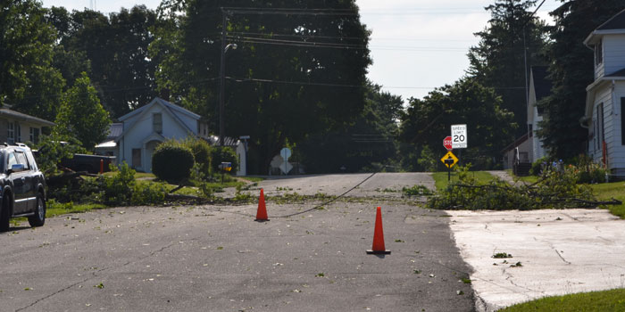
KOSCIUSKO — The National Weather Service has issued a wind advisory for Kosciusko, Fulton, Elkhart and Marshall counties. The advisory will be in effect from 5 a.m. until 8 p.m. on Thursday, April 6. Hazardous weather is expected to bring north winds gusting up to 45 mph. These conditions will likely cause scattered trees and limbs …read more.
KOSCIUSKO COUNTY — The National Weather Service has issued a fog warning for Kosciusko County and surrounding areas. Fog will persist through the evening hours with some spots of dense fog with visibilities of one quarter mile or less. The NWS warns that individuals should use caution if driving this evening. The conditions are expected …read more.
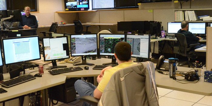
NORTHERN INDIANA — (EDITOR’S NOTE: This is the second in a four-part series on the National Weather Service, Northern Indiana) “It’s a machine,” said Michael Lewis, warning coordination meteorologist at the National Weather Service, Northern Indiana, about the Doppler Radar. But the radar is just one tool in forecasting weather and what people see when …read more.
KOSCIUSKO COUNTY — The National Weather Service has issued a severe thunderstorm watch for Kosciusko, Allen De Kalb, Elkhart, Fulton, LaGrance, La Porte, Marshall, Noble, Pulaski, St. Joesph, Starke, Steuben and Whitley Counties. The watch will go into effect until 4 a.m. EST, Wednesday, March 1.
KOSCIUSKO — The National Weather Service has issued a hazardous weather outlook for Kosciusko for this evening. Severe thunderstorms are possible, especially after 8 p.m. and becoming scattered after 10 p.m. The primary threat is damaging wind gusts, especially along and south of US 30. Small hail is also possible and locally heavy rainfall may …read more.
KOSCIUSKO COUNTY — The National Weather Service for Northern Indiana has issued a severe thunderstorm watch. The counties impacted are widespread and include Kosciusko, Elkhart, Fulton, Marshall and Noble counties. The watch will remain in effect until 10 p.m. A full list of counties impacted can be viewed here. The National Weather Service offers the …read more.
WARSAW — The National Weather Service has issued a dense fog advisory for Kosciusko County, including Warsaw, Winona Lake and Syracuse, until 1 a.m. Tuesday. Widespread fog with areas of dense fog can be expected through this evening. According to the NWS, visibility will be a quarter mile or less at times. Hazardous driving conditions are …read more.
KOSCIUSKO COUNTY — Kosciusko County is included in a hazardous weather outlook issued by the National Weather Service for this weekend. A few degrees can mean the difference between rain or snow, so freezing rain and ice can be difficult for forecasters to pinpoint far in advance. A wintry mix of snow, sleet and freezing rain …read more.
The advisory has been extended until 11 a.m., Tuesday, Jan. 10. KOSCIUSKO COUNTY — The National Weather Service of Northern Indiana has declared a winter weather advisory for Kosciusko, Marshall, Whitley, Allen and Elkhart counties. The advisory goes will last from 1 to 7 a.m. on Tuesday, Jan. 10. A mixture of snow, sleet and …read more.
KOSCIUSKO COUNTY — As we head into the New Year and weekend celebrations, the National Weather Service is predicting a clear and relatively warm weekend. Highs Dec. 31 and Jan. 1 will be around 40. There is a slight chance of snow showers Saturday, with a 20 percent chance after 2 p.m. Expect some heavy winds with …read more.
KOSCIUSKO COUNTY — A Wind chill advisory is in effect from now until noon on Monday, Dec. 19. Counties under the advisory include Kosciusko, Lagrange, Steuben, Noble and Fulton. The National Weather Service anticipates temperatures from 10 to 20 degrees below zero. Bitterly cold wind chill values are expected that can cause frostbite to exposed …read more.
WARSAW —The National Weather Service has issued a winter weather advisory to be in effect from 4 p.m. EST Friday, Dec. 16, until 7 a.m. EST Saturday, Dec. 17. Warsaw, Winona Lake, Syracuse, Mentone, Plymouth, Columbia City and other area towns are included in this advisory. According to the NWS, snow will develop by late …read more.
WARSAW — A wind child advisory will go into effect for Akron, Warsaw, Winona Lake, Syracuse, Mentone, Columbia City and many other area towns from 10 p.m. EST tonight, Dec. 14, until 1 p.m. EST Thursday, Dec. 15. According to the National Weather Service, wind chill temperatures of 15 below zero to 20 below zero …read more.
KOSCIUSKO COUNTY — A cool but fairly dry weekend is in the forecast for most of Kosciusko County, according to the National Weather Service of Northern Indiana. A couple of weak disturbances tracking across the Great Lakes today will result in a chance of some light rain showers across far northern Indiana. Otherwise, skies will remain …read more.
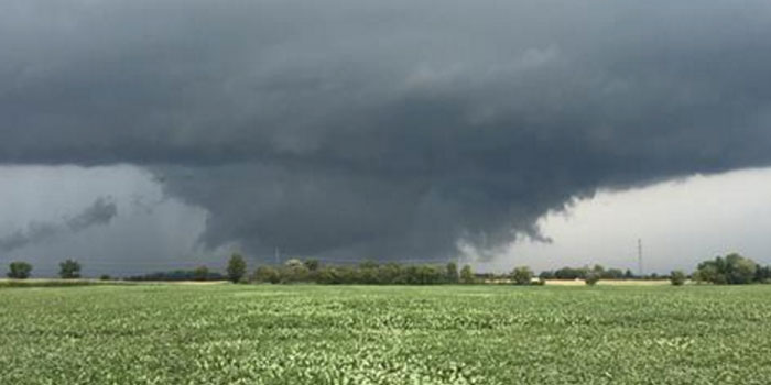
HOWARD COUNTY — The National Weather Service confirmed that an EF3 tornado touched down in Kokomo Wednesday afternoon, with winds up to 165 mph.
SYRACUSE — The National Weather Service has confirmed a small, EF0 tornado in southern Elkhart County, near Syracuse, yesterday, Saturday, Aug. 20. The funnel touched down just south of US 6, near CR 133, causing minor damage to two homes, several trees and a cornfield. It was on the ground for about a minute. EF0 …read more.
NORTHERN INDIANA — The National Weather Service of Northern Indiana has issued a flash flood watch beginning at 2 p.m. Monday, Aug. 15, through Tuesday morning, Aug. 16. The watch has been issued for portions of northern Indiana and southwestern Michigan, including Kosciusko County, ELkhart County, Fulton County, Whitley County, Marshall County, Cass County, LaPorte …read more.
NORTHERN INDIANA — The National Weather Service in Northern Indiana has issued the following special weather statement for Kosciusko and surrounding counties: Atmospheric conditions are favorable for the development of funnel clouds associated with rain showers and thunderstorms across the area. These funnel clouds normally protrude a few hundred feet downward from the parent cloud, …read more.
NORTHERN INDIANA — The National Weather Statement has issued a special weather statement for Kosciusko and surrounding coutnies. A line of strong thunderstorms was spotted extending from near LaGrange to near Syracuse to near Argos and moving southeast at 35 miles per hour. Wind gusts up to 50 miles per hour and pea-sized hail are …read more.
KOSCIUSKO COUNTY — A heat advisory issued by the National Weather Service of Northern Indiana will last into the weekend as temperatures continue to reach into the high 90s. The advisory is in effect for Kosciusko and surrounding counties through 7 p.m. Saturday, July 23, however, dangerous heat and humidity may continue into Sunday, July 24. …read more.
NORTHERN INDIANA — The National Weather Service of Northern Indiana has issued a heat advisory, effective from 2 p.m. Thursday, July 21, until 8 p.m. Saturday, July 23, for Kosciusko and surrounding counties. Highs are expected to reach from the upper 80s to the mid-90s Thursday through Saturday. Lows will dip into the 70s at …read more.
KOSCIUSKO COUNTY — The National Weather Service has issued a special weather statement regarding a line of strong thunderstorms moving into the Kosciusko County area. The storm is expected to contain wind gusts of up to 50 miles per hour with torrential rainfall. A severe thunderstorm watch is also in effect for Kosciusko and surrounding counties …read more.
KOSCIUSKO COUNTY — With tornado watches and at least one warning issued last evening, Wednesday, June 22, the National Weather Service says it will be a while before any confirmations can be made. According to Mark Steinwedel, meteorologist with the National Weather Service, while radar picked up rotation in the southern part of the county, a careful assessment …read more.
KOSCIUSKO COUNTY — While Kosciusko County and surrounding counties remain under a hazardous weather outlook, areas to the west are beginning to see an increase in severe weather risk. The National Weather Service has issued a tornado watch for several counties along the western edge of Indiana, including Benton, Newton, Jasper, Porter and Lake counties. This will …read more.

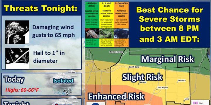
[weaver_youtube IjbMN6mHb0M rel=0] NORTHERN INDIANA — The National Weather Service of Northern Indiana is predicting severe storms for this evening with a possibility of what meteorologists are calling, “significant tornadoes” south of U.S. 30. Aside from the possibility of tornadoes, damaging wind gusts, hailstones measuring up to 1 inch in diameter and flooding could all occur with …read more.
NORTHERN INDIANA — The National Weather Service has issued a flood warning for the Eel River at North Manchester, affecting Kosciusko, Whitley, Cass, Miami and Wabash Counties. Rainfall this evening is expected to cause the Eel River at North Manchester to rise above flood stage. The flood stage for the Eel River is 9 feet. …read more.

NORTHERN INDIANA — Yesterday’s storms may have blown over, but that does not mean Kosciusko County and the surrounding area is in the clear just yet. The National Weather Service is predicting more severe weather moving into Kosciusko County and the surrounding area tomorrow, Wednesday, June 22. While the risk is classified as “moderate,” NOAA’s Storm Prediction …read more.
NORTHERN INDIANA — The National Weather Service of Northern Indiana has issued a hazardous weather outlook today, Monday, June 20, for Kosciusko and surrounding counties. Heat indices are expected to reach into the low- to mid-90s range. Scattered, isolated thunderstorms could develop after 2 p.m. and some could be strong or severe. Click here for …read more.
NORTHERN INDIANA — The National Weather Service has issued a hazardous weather outlook for Kosciusko and surrounding counties. This means there is a slight chance for showers throughout the day, with thunderstorms this afternoon and evening; it does not mean severe weather is currently expected. There is also a chance for an occasional thunderstorms through Sunday …read more.
NORTHERN INDIANA — The National Weather Service of Northern Indiana has issued a hazardous weather outlook for Kosciusko County and surrounding counties, including but not limited to Whitley, Elkhart, Fulton, Allen and Marshall. Snow showers are expected throughout the northern Indiana area this afternoon and wind and snow could cause reduced visibility in some areas. Isolated thunderstorms …read more.
NORTHERN INDIANA — The National Weather Service in Northern Indiana has issued a hazardous weather outlook for much of the area, including Kosciusko and surrounding counties. Thunderstorms are likely this afternoon, Thursday, March 31. Some of these thunderstorms may be severe, with large hail and isolated damaging winds. Windy conditions are also predicted Friday through …read more.
NORTHERN INDIANA — The National Weather Service has issued a special weather statement for Kosciusko, Elkhart, Marshall, Fulton, Noble, Whitley, Wabash county and surrounding counties. These counties should expect low temperatures during the next week to 10 days. Temperatures are expected to drop into the middle and upper 20s at times, with temperatures as low …read more.
NORTHERN INDIANA — The National Weather Service Northern Indiana has issued a special weather statement and hazardous weather outlook for Kosciusko, southern Marshall, Fulton counties as well as portions of Starke, Pulaski, White and Counties. Portions of Elkhart and Noble counties are in a severe thunderstorm warning. NWS reported a line of strong thunderstorms will …read more.
NORTHERN INDIANA — March 20-26 is Indiana’s Severe Weather Preparedness Week and Kosciusko County Emergency Management wants to make sure local residents are ready when severe weather strikes. Earlier this month, March 1-7, the National Weather Service observed National Severe Weather Preparedness Week. Statewide tornado drills are taking place throughout the day today, Tuesday, March 22. While there are a …read more.
NORTHERN INDIANA — The National Weather Service in Northern Indiana has issued a wind advisory for Kosciusko, Whitley, Allen, Fulton, Elkhart, Marshall, St. Joseph, LaGrange, Wabash and surrounding counties. The advisory is in effect from 8 a.m. to 8 p.m. Wednesday, March 16. Southwest winds are expected at up to 30 miles per hour with gusts …read more.
NORTHERN INDIANA — The National Weather Service of Northern Indiana has issued a hazardous weather outlook for Kosciusko, Whitley, Allen, St. Joseph, Elkhart, LaGrange, Fulton, Marshall, Pulaski, Starke, Noble, DeKalb, Cass, Miami, Wabash and White Counties. Light snow is expected to overspread the region late tonight. Some light freezing rain or freezing drizzle may also …read more.
NORTHERN INDIANA — The National Weather Service has issued a hazardous weather outlook for portions of northwest Ohio and northern Indiana on Tuesday. The counties included include Noble, DeKalb, Starke, Pulaski, Marshall, Fulton, Kosciusko, Whitley, Allen, White, Cass, Miami, Wabash, Huntington, Wells, Adams, Grant, Blackford, Jay and Fulton counties in Indiana. A mix of snow, …read more.
NORTHERN INDIANA — The National Weather Service winter storm warning is still in effect until 4 p.m. There will be light snow with additional accumulations of an inch or less and tapering off early this afternoon. Northwest winds of 20 to 30 miles per hour will diminish slightly this afternoon to between 15 and 25 …read more.
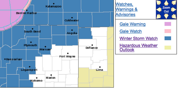
NORTHERN INDIANA — The National Weather Service Northern Indiana issued a winter storm watch in effect from Wednesday morning, Feb. 24, through Thursday afternoon, Feb. 25. A mix of rain and snow changing to all snow late Wednesday morning through Wednesday afternoon and continuing into Thursday. The storm total snowfall accumulations of 4-8 inches is …read more.
NORTHERN INDIANA — The National Weather Service of Northern Indiana has issued a special weather statement for much of northern Indiana, including Kosciusko, Marshall, Starke, Noble, Lagrange, Elkhart, St. Joseph and LaPorte Counties. Patchy freezing drizzle is expected early this evening, Monday, Feb. 15. Patchy freezing drizzle may cause a few slick spots on roads and …read more.
NORTHERN INDIANA — The National Weather Service office in Fort Wayne is predicting lake-effect snow squalls that will drop new snow across north central and northeast Indiana through Saturday. Another weather system brings increasing snow chances statewide beginning on Sunday. Indiana Department of Transportation maintenance supervisors will continue to monitor evolving weather forecasts this weekend. …read more.
NORTHERN INDIANA — The National Weather Service has issued a hazardous weather outlook for the following counties: Kosciusko, Marshall, LaGrange, Noble and St. Joseph. This includes the areas of Warsaw, Winona Lake, Syracuse, Mentone, Plymouth, Bremen, Culver, LaGrange, Topeka, Shipshewana, Kendallville, Ligonier and Albion and portions of southern Michigan. Lake-effect snow showers will diminish later …read more.
KOSCIUSKO COUNTY — The National Weather Service has issued a special weather statement warning drivers of possible slick spots on the roads.[weaver_sc id=”surveybegin”] A combination of wet pavement, patchy fog and temperatures hovering around the freezing mark may create some slick spots on roadways through 10 a.m. this morning, Monday, Feb. 1. Pedestrians should also use caution, …read more.
KOSCIUSKO COUNTY — It didn’t take a thermostat this morning for many people in Kosciusko County to realize temperatures had once again plummeted. The National Weather Service has issued a special weather statement in response to the low temperatures. According to the NWS, temperatures in the lower, single digits just above zero and southwest winds …read more.
NORTHERN INDIANA — The National Weather Service of Northern Indiana has issued a winter weather outlook for Kosciusko County and the following surrounding counties: Marshall, Elkhart, Noble, Whitley, Wabash and Fulton. The Marshall County Sheriff’s Department and Noble County EMA and 911 Center have issued the following statement for their areas: A winter storm watch …read more.
https://www.youtube.com/watch?v=5f7N-PiX_Zs The National Weather Service of Northern Indiana has issued a winter storm watch in effect from Saturday, Jan. 9, to Sunday, Jan. 10, for Marshall County. According to the NWS, snow is expected to spread across the area Saturday night as a strong low pressure system moves northeast through the Ohio Valley. The snow …read more.
NORTHERN INDIANA — The National Weather Service has issued freezing rain and wind advisories and a hazardous weather outlook, all in effect throughout today, Monday, Dec. 28. The freezing rain advisory lasts until 4 p.m. and includes light ice accumulations up to 1/10 of an inch. The freezing rain is expected to change to rain later …read more.
The National Weather Service in Northern Indiana has issued a freezing rain advisory, which is in effect from 7 a.m. to 4 p.m. Monday, Dec. 28, and a wind advisory from 10 a.m. to 10 p.m. Monday. The freezing rain advisory is for Noble, DeKalb, Starke, Pulaski, Marshall, Fulton, Kosciusko, Whitley and Allen counties. Freezing …read more.
NORTHERN INDIANA — The National Weather Service Northern Indiana has issued a flash flood watch for Northern Indiana through Monday afternoon. Additionally information on a hazardous weather outlook has been posted. While rain will taper off today, run-off from heavy rain on Saturday may still result in some flooding. Flash flooding of low lying or …read more.
UPDATE — The severe thunderstorm warning has been extended until 3:30 p.m. for northeastern Kosciusko County. The National Weather Service is now stating the intense thunderstorm lines can produce brief tornadoes and widespread significant wind damage. Although a tornado is not immediately likely, it is best to move to an interior room on the lowest …read more.
The National Weather Service has issued a winter storm warning, in effect until 10 p.m. Saturday, Nov. 21, for Kosciusko and surrounding counties. Heavy snow is expected at times and will continue through the day before tapering off early this evening. Snow accumulations are expected from 4-7 inches through the evening. Snow covered roads …read more.

INDIANA — This has been Winter Weather Preparedness Week in Indiana. The National Weather Service, with its partners in state and local government and the Red Cross, urge residents to be prepared for winter. It is each person’s responsibility to ensure to have plans and act safely when hazardous weather occurs. The NWS encourages all …read more.
NORTHERN INDIANA — Elkhart County along with St. Joseph, LaGrange, LaPort, Steuben counties in Indiana and Berrien, Cass, St. Joseph, Branch and Hillsdale counties in Michigan are under a winter storm watch from Saturday morning through Saturday evening according to the National Weather Service Northern Indiana.

The weather outlook for Indiana this winter favors near to above normal temperatures and less precipitation than normal. Expect mild and cold periods. Also snow and rain are likely and an ice storm is possible though precipitation is expected to be below average. Snowfall could even end up above average. Whatever weather occurs, everyone must …read more.
INDIANA — This week is Winter Weather Preparedness Week in Indiana. How should you drive when snow occurs? What should you do if stranded by a blizzard or ice storm? Are you weather ready?

INDIANA — The outlook for winter indicate odds favoring above normal temperatures and below normal precipitation for Indiana.
INDIANA — Gov. Mike Pence has proclaimed Nov. 15-21 as Winter Weather Preparedness Week in Indiana.
The weather in Kosciusko has been blustery and cold since yesterday evening. As traditional with Indiana weather, temperatures have dipped and risen throughout the month. Tomorrow however, will yield the season’s first potential snowfall in the area. As snowfall predictions begin to roll in for Friday, experts are beginning to project the season’s outlook as well. …read more.
NORTHERN INDIANA — The National Weather Service in Northern Indiana has issued a wind advisory, which is in effect until 9 p.m. today, Thursday, Nov. 12. The high wind warning has been cancelled.
NORTHERN INDIANA — The National Weather Service in Northern Indiana has issued a high wind warning in effect from 1 a.m. through 10 p.m. Thursday, Nov. 12. Counties throughout northern Indiana, into Ohio and Michigan are under this watch.
NORTHERN INDIANA — The National Weather Service in Northern Indiana has issued a high wind watch in effect from late tonight, Nov. 11 through Friday morning. Counties throughout northern Indiana, into Ohio and Michigan are under this watch.
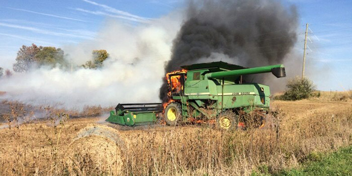
By JEFF BURBRINK, Extension Editor On Monday, Oct. 19, the National Weather Service issued a Red Flag Warning, which indicates the conditions were right for fires to spread rapidly due to dry conditions and wind. While conditions are expected to improve slightly over the next week, the fact is the fields are very dry …read more.
The National Weather Service in northern Indiana has issued a freeze warning, in effect from 11 p.m. Saturday, Oct. 17, to 9 a.m. Sunday, Oct. 18. This affects Kosciusko and surrounding counties, including but not limited to Elkhart, Marshall, Fulton, Whitley, Allen, Miami, Wabash and Noble. A freeze warning means sub-freezing temperatures are imminent or highly …read more.
WARSAW — The National Weather Service has issued a freeze warning for Kosciusko County, in effect from 2-9 a.m. Saturday, Oct. 17, with a freeze watch in effect Saturday evening through Sunday morning. Other counties in the area under the warning include Fulton, Marshall, Allen, Wabash, Whitley and Noble. Click here for the full listing …read more.

KOSCIUSKO COUNTY — The Indiana Department of Transportation announces that SR 13 will be closed .4 miles north of East CR 800N beginning Tuesday, Oct. 13, weather permitting.
NORTHERN INDIANA — The National Weather Service has issued a special weather statement at 11:29 p.m. Friday, Aug. 14.
KOSCIUSKO — The National Weather Service has issued a severe thunderstorm watch in effect until 2 a.m. Monday, Aug. 3, for Kosciusko and surrounding counties.
The National Weather Service Storm Prediction Center, Norman, Okla., has issued a tornado watch until midnight for Kosciusko, Elkhart, Fulton, Noble, Marshall and Whitley counties. Other counties included in the watch are Adams, Cass, Jay, LaPorte, Starke, Wells, Allen, DeKalb, Grant, Pulaski, Steuben, White, Blackford, Huntington, LaGrange, Miami, St. Joesph and Wabash counties. The National …read more.
Extreme heat is on the horizon for Kosciusko County this weekend. The National Weather Service has issued a hazardous weather outlook for Kosciusko and surrounding counties. Today, thunderstorms are possible throughout the day and early tonight. An isolated strong or severe storm is possible along with localized heavy rain this afternoon and evening. This heat …read more.
UPDATE: Southern Kosciusko County has now been placed under a severe thunderstorm warning until 10 p.m. Other counties include Fulton County, northwestern Miami County and northern Wabash County Locations impacted include Rochester, North Manchester, Akron, Mentone, Kewanna, Claypool, Macy, Burket, Signey, Disko, Leiters Ford, Tiosa, Ijamsville, Talma, Nyena Lake, Beaver Dan, Liberty Mills, Bruce Lake …read more.
The National Weather Service has issued a hazardous weather outlook for portions of northern Indiana. Severe thunderstorms are possible throughout the day and into the night. Heavy, damaging winds could accompany the storms. There is also a risk of large hail, and isolated tornadoes could touch down. Heavy rainfall may come down throughout the day, …read more.
According to the National Weather Service, a hazardous weather outlook is in effect until early next week. According to the NWS, there will be periodic chances for thunderstorms from Saturday through Thursday. The best chance of thunderstorms appears to be from Saturday evening through Sunday morning. Chances peak again from late Sunday night into Monday. …read more.
The National Weather Service has issues a hazardous weather outlook for portions of northern Indiana. Scattered and numerous thunderstorms are expected from late this morning through the evening. Thunderstorms could be severe in the evening, with heavy wind gusts. Hail is also possible. Heavy downpours could add to flooding issues already affecting the area. Additionally, …read more.

UPDATE: Since the rain started, we have received reports of areas with standing water. A vehicle reportedly got stuck under the viaduct on Columbia Street. Several cars have been reported stalling out at intersections along Detroit Street through downtown Warsaw. Please use caution until water subsides. If you come upon an area of standing water, …read more.
The National Weather Service in Northern Indiana has issued a flood advisory for urban and small streams in central Marshall County and northern Kosciusko County until 1 a.m. Thursday, June 11. At 9:54 p.m. doppler radar indicated heavy rain due to thunderstorms that will cause urban and small stream flooding in the advisory area. Up …read more.
The National Weather Service has extended the severe thunderstorm watch to 1 a.m. Monday, June 8 Among the counties in the severe thunderstorm watch are Kosciusko, Cass, LaPorte, Pulaski, Fulton, Marshall, Whitley, Allen, Huntington, Starke, Miami, Wabash and White counties. Thunderstorms are possible across southwest Michigan into Northwest Indiana. The storms will move east into …read more.

By JOHN E. HART Hoosier Lakes Radio Club Public Information Officer Field day is coming soon June 27 and June 28. What is field day? The purpose of this event is training and a demonstration of emergency preparedness in radio communications. Amateur radio also known as ham radio. In case of a crisis or an …read more.

An EF-1 tornado has been confirmed to have hit in Indianapolis Saturday night, May 30. The affected area, a subdivision off Southeastern Ave. on the southeast side of the city, saw damage ranging from downed tree limbs to several houses that are likely destroyed. The National Weather Service confirmed the tornado on Sunday, May 31, …read more.
UPDATE: The hazardous weather outlook has been upgraded to a severe thunderstorm warning. A severe thunderstorm could move through Kosciusko County. Strong winds and hail could accompany the storm. Should the storm hit in your area, move to an interior room on the lowest floor of the building. Flash flooding could occur. NWS warns not …read more.
The National Weather Service has issued a special weather statement for portions of northern Indiana. Thunderstorms are expected across northeast Indiana this afternoon and through the evening. Storms could be accompanied by damaging winds. NWS reports that stronger storms could produce winds up to 50 mph. There is also a slight chance of small hail. …read more.
The National Weather Service has issued a severe thunderstorm watch for the area. The watch is in effect until 10 p.m. tonight. NWS reports that thunderstorms are likely through the afternoon and into the evening. These storms could be accompanied by high winds, which could cause damage. Thunderstorms are possible on Wednesday as well. At …read more.
The National Weather Service has issued a tornado watch for parts of northern Indiana. The watch is in effect until 8 p.m. tonight. Kosciusko, Elkhart, Noble, Whitley and Wabash Counties are affected by the tornado watch. A watch does not indicate that a tornado is happening, only that atmospheric conditions could create a tornado. Additionally, …read more.
The National Weather Service has issued a hazardous weather outlook for Kosciusko and surrounding counties. According to the NWS, chances for thunderstorms will increase late this morning and into the afternoon in advance of a cold front moving through the area. A few thunderstorms have the chance to become strong to severe in the afternoon …read more.
The National Weather Service has issued a frost advisory for Kosciusko and area counties from 2 a.m. to 9 a.m. Tuesday, April 28. According to the NWS, temperatures are expected to drop into the low to mid 30s tonight. Frost formation is likely once skies clear and winds diminish. The NWS notes that sensitive vegetation …read more.
The National Weather Service has issued a hazardous weather outlook for Kosciusko and surrounding counties. According to the NWS, west winds of 15 to 25 mph with gusts of 35 to 40 mph are expected late this morning and afternoon. Lows are expected to be in the lower 30s tonight with frost and sub-freezing temperatures …read more.
The National Weather Service has issued a wind advisory, which is in effect from 11 a.m. to 8 p.m., for Kosciusko and surrounding counties. According to the NWS, strong winds of 20 to 30 mph are expected from the west with frequent gusts up to 45 mph expected late this morning and into the afternoon. …read more.
As of noon today, the National Weather Service has issued a red flag warning for northern Indiana. The warning indicates critical fire conditions are occurring. Winds up to 20 mph out of the east combined with relatively low humidity means wildfires could start easily and spread quickly. Burning is not recommended throughout the afternoon and …read more.
The National Weather Service in Northern Indiana has extended today’s wind advisory to 8 p.m. for Kosciusko and surrounding counties. According to the NWS, strong west winds between 25 and 35 mph are expected with frequent gusts up to 45 mph are expected later this afternoon and into the early evening. The NWS warns that …read more.

With a potentially volatile midweek forecast that includes severe storms, heavy rains, strong winds and the potential for tornadoes, the U.S. Department of Homeland Security’s Federal Emergency Management Agency encourages everyone to get prepared. The National Weather Service Northern Indiana has posted a hazardous weather outlook. on its site: http://www.weather.gov/iwx/ Thunderstorms are expected today and tonight …read more.
With temperatures reaching 60 degrees and higher today in the Kosciusko County area, the National Weather Service has issued a special weather statement warning of a heightened fire danger through the afternoon. A dry air mass remains across the area causing humidity values to drop to 25 to 30 percent in some spots. Combined with …read more.
The National Weather Service has issued a special weather statement for Kosciusko and surrounding counties in regard to scattered thunderstorms moving through the area. According to the NWS, doppler radar has indicated showers and scattered thunderstorms along a line extending from Warsaw to 18 miles south of Grissom Airforce Base is moving east at 40 …read more.
The National Weather Service has issues a hazardous weather outlook and special weather statement for northern Indiana. Periods of snow can be expected during the day throughout the region. Accumulations of 1 to 3 inches may be possible on grassy areas, and slick road conditions could occur during heavier periods of snowfall. The snow is …read more.
The National Weather Service has issued a hazardous weather outlook for portions of northern Indiana. Melting snow combined with frozen ground is expected to water ponding in areas with poor drainage. Additionally, rapid river level rises could occur in areas prone to ice jams. Kosciusko, Elkhart, Marshall, Fulton, Whitley and Noble Counties are affected by …read more.
National Weather Service Northern Indiana has extended the dense fog advisory until noon today. Advisory includes Kosciusko, Whitley, Fulton, Marshall counties Dense fog is limiting visibilities to less than one-fourth mile through late morning and will cause hazardous driving conditions and travel delays. There have been fog related accidents reported in the advisory area. NWS …read more.
A winter weather advisory is now in effect until 1 p.m. according to the National Weather Service Northern Indiana for Kosciusko, Marshall, Fulton, Whitley, Wabash counties along with Noble, DeKalb, Stark, Pulaski, Allen, White, Cass, Miami, Hunting, Wells, Adams, Grant counties. Freezing rain will spread across the area this morning with ice accumulations around one-tenth …read more.
The National Weather Service in northern Indiana has issued a winter weather advisory for freezing rain and sleet, which is in effect from 6 a.m. to 1 p.m. Tuesday. According to the NWS, freezing rain will spread from the southwest at 6 a.m. to the northeast by 9 a.m. The precipitation will start as a …read more.
The National Weather Service has issued a special weather statement for portions of northern Indiana. Gusty winds out of the southwest have the potential to bring blowing and drifting snow to the area. These winds are expected to persist throughout the afternoon. Winds of 15 to 25 mph, with heavy gusts up to 35 mph, …read more.
The National Weather Service in northern Indiana has issued a winter weather advisory for snow and blowing snow in effect for Kosciusko and area counties until 10 p.m. According to the NWS, bands of light to moderate lake effect snow will develop this afternoon and persist through mid-evening. Snow accumulations of 1 to 2 inches …read more.