Tag: National Weather Service
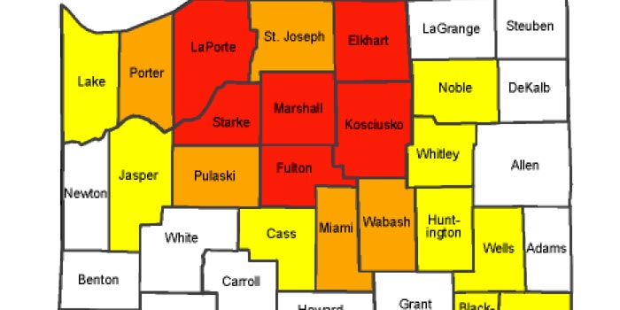
The Kosciusko County Commissioners and Kosciusko County Emergency Management have issued a “Red” Warning Level regarding roadway travel. This is the highest level of local travel advisory. Travel is restricted to emergency management workers only. It is recommended that everyone should refrain from any travel. Additionally, the National Weather Services has put Kosciusko County us …read more.
The National Weather Service in northern Indiana has issued a winter weather advisory for snow and blowing snow for Kosciusko County to be in effect from 7 a.m. Saturday to 7 a.m. Sunday. According to the NWS, 1-4 inches of lake effect snow accumulation will occur mostly Saturday afternoon into Saturday night. While only light …read more.
The National Weather Service has issued a hazardous weather outlook for portions of northern Indiana. Lake effect snow is expected later tonight. Heaviest accumulations are expected in St. Joseph and La Porte Counties, but Kosciusko, Elkhart, Marshall and Fulton Counties will also be affected by these weather patterns. There is a possibility of blowing snow …read more.
The National Weather Service in northern Indiana has issued a winter weather advisory for snow, in effect from 12 p.m. to 7 p.m. today. According to the NWS, snow accumulations of 2-4 inches are expected with locally higher amounts possible. Snow may be briefly heavy at times with reduced visibilities. Untreated roads will become slippery …read more.
At 4 a.m. this morning, the National Weather Service issued another winter storm warning for Kosciusko, Marshall, Fulton, Whitley, Elkhart, Noble, Allen and St. Joseph Counties. Light snowfall, along with blowing and drifting snow, is expected to continue to make travel difficult, especially on east-west roads. Unplowed areas may be impassable. Travel is only recommended …read more.
UPDATE: The National Weather Service has changed the possible snow accumulation totals from 7 to 11 inches to 10 to 15 inches. Please use caution while traveling this evening and tomorrow. The National Weather Service has issued a Winter Storm Warning in effect from 7 p.m. this evening to 4 a.m. Monday for the following …read more.
The National Weather Service has issued a Winter Storm Watch in effect from Saturday evening through Sunday evening for the following area counties: Kosciusko, Elkhart, Marshall, Fulton, Allen, Noble, Wabash and Miami. According to the NWS, heavy snowfall is expected with snowfall totals of 6-12 inches possible. Blowing and drifting snow, especially Sunday afternoon and …read more.
According to the National Weather Service, Warsaw’s Thursday night weather prediction calls for a chance of drizzle, snow showers, and freezing drizzle before 10 p.m., then a chance of snow showers. Cloudy, with a low around 20 degrees. There is expected to be a northwest wind between 15 to 20 miles per hour, with gusts as …read more.
The National Weather Service in Northern Indiana has issued a freezing rain advisory in effect from 4 a.m. to 9 a.m. Thursday. According to the NWS, freezing rain is expected to develop later tonight into early Thursday morning before temperatures warm above freezing. Some snow and sleet may mix in at times. Light icing is …read more.
For those interested in weather and weather patterns an exciting opportunity is being provided by the National Weather Service’s Northern Indiana division. The annual spotter training class is just around the corner, and individuals are encouraged to register to attend and learn about how to report their personal observations to the National Weather Service for …read more.
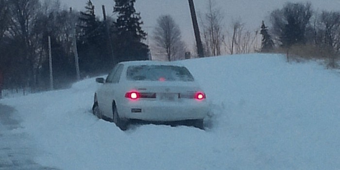
If you haven’t already noticed, the roads in and around Kosciusko County are a little rough this morning. Kosciusko County is currently under a advisory level travel advisory, which means roads could be slick and snow covered. “With the wind they’re calling for today, I don’t see it getting any better,” says Ed Rock of …read more.
The National Weather Service in northern Indiana has issued a winter weather advisory for snow and blowing snow effective until 4 p.m. Friday. Dangerous cold conditions are expected with wind chills 10 to 25 below zero Friday into Saturday morning. According the the NWS, snow will develop late this afternoon or early this evening and …read more.
A wind chill warning was issued at 6:10 a.m. today by the National Weather Service and will be in effect from 10 p.m. this evening until noon Thursday. The winter weather advisory has been cancelled. In addition to Kosciusko County, other counties include Whitley and Allen counties. The snow will taper and end this morning, …read more.
The National Weather Service in Northern Indiana has issued a winter storm watch, which is in effect from Monday evening through Tuesday morning. The watch includes LaGrange, Noble, DeKalb, Kosciusko and Whitley counties. Snow is expected to move into the area Monday evening and continue into Tuesday morning. Snowfall amounts of 3 inches to 6 …read more.
The National Weather Service Northern Indiana issued a special weather statement and hazardous outlook this morning for the area, including Kosciusko County, for a winter weather outlook for accumulating snow and bitterly cold wind chills. Other counties included are LaPorte, St. Joseph, Elkhart, LaGrange, Steuben, Noble, DeKalb, Stark, Pulaski, Marshall, Fulton, Whitley, Allen and further …read more.
The National Weather Service in Northern Indiana has issued a winter weather advisory for snow, sleet and freezing rain from 3 a.m. to 1 p.m. Saturday. The winter weather advisory includes: Noble, DeKalb, Stark, Pulaski, Marshall, Fulton, Kosciusko, Whitley, Allen, Defiance, Henry, Paulding and Putnam counties. The NWS reports a period of snow, sleet and …read more.
The National Weather Service (NWS) has issued a freezing fog advisory in northern Indiana until 7 a.m. Saturday, Dec. 13. According to the NWS, areas of freezing fog with some patchy freezing drizzle will lead to slick spots on walkways and roadways. Localized visibilities are expected to be limited to a quarter of a mile. …read more.
The National Weather Service has just issued a special weather statement for northern Indiana and southern Michigan. Areas of heavy fog are expected in much of this area throughout the evening. The statement warns that visibility could be as low as a quarter mile in some areas. Additionally, with temperatures hoovering right around the freezing …read more.
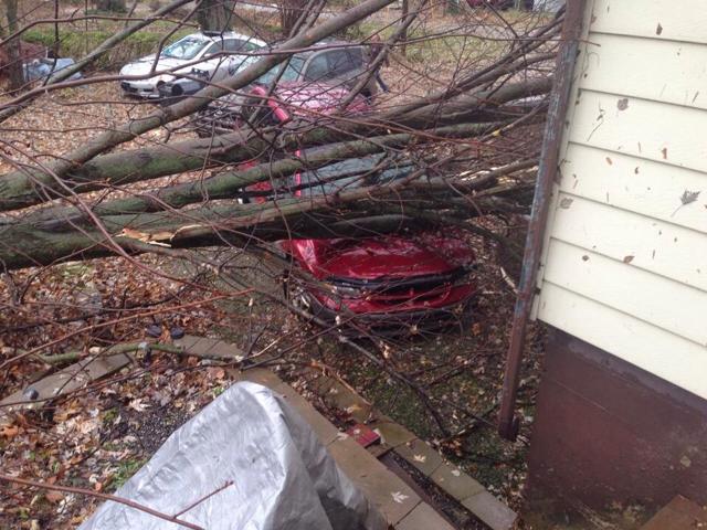
The National Weather Service has now issued a high wind warning for Kosciusko and surrounding counties. This advisory is in effect until 7 p.m. this evening. The strong winds have caused trees and branches to fall into roads and power lines across the county. Southwest winds will increase to 35 to 45 mph with wind …read more.
The National Weather Service of Northern Indiana issued a special weather statement at 5:08 a.m. this morning for a large number of counties including Kosciusko. A period of light freezing rain is likely late tonight into early Saturday morning. The light freezing rain is expected to move into far northwest Indiana after midnight and then …read more.
The Northern Indiana Blizzard of 1978 is the worst on record in Hoosier history. It proved to be the first winter storm where a blizzard storm warning was issued for the entire state at 3:45 p.m. Jan. 25, 1978. Over the several day span of the storm, temperatures dipped to 4 degrees while winds created …read more.
At approximately 10 a.m. this morning, the National Weather Service issued a hazardous weather outlook for portions of northern Indiana and southwest Michigan. The outlook projects that wind chills will fall to between 0 degrees and 10-below later this evening. Wind chill temperatures are expected to be below zero for much of Tuesday as well. …read more.
The National Weather Service (NWS) has issued a special weather statement to be in effect until 8 p.m. this evening for Kosciusko and Whitley counties. According to the NWS, snow will continue to spread throughout northern Indiana late this afternoon and early this evening as an upper level disturbance tracks into the region. The accumulating …read more.
The National Weather Service has issued a hazardous weather outlook and special weather statement for the Kosciusko County area — specifically noting the cities of Ligonier, Plymouth, Bremen, Culver, Warsaw, Winona Lake, Syracuse, Mentone, Columbia City, South Whitley and Fort Wayne. According to the NWS, lake effect snow showers will increase throughout the day and …read more.
As trick-or-treaters prepare to don their costumes throughout Kosciusko County this evening, parents may also want to grab a coat and umbrella. The National Weather Service is predicting both rain and showers today with a high near 42 degrees. According to the NWS, rain or snow showers are likely before 10 p.m., then scatter snow …read more.
The National Weather Service has issued a freeze warning for northern Indiana, including Kosciusko, Elkhart, Whitley, Wabash, and St. Joseph Counties. The warning is in effect from 4 a.m., Sunday, Oct. 19, until 9 a.m. the same day. According to the warning: clearing skies and diminishing winds will cause temperatures in the region to drop …read more.
The National Weather Service (NWS) has issued a United States Winter Weather Outlook for the upcoming winter season. Though many have worried that last year’s extreme cold and snowy winter would make a return this season, the National Weather Service reports this is unlikely. “Last year’s winter was exceptionally cold and snowy across most of …read more.
The National Weather Service in Northern Indiana has issued a severe thunderstorm warning for east central Fulton County, southern Kosciusko County and Northern Wabash County effective until 4:30 p.m. At 3:50 p.m. a severe thunderstorm was located near Rochester moving east at 20 mph. Reports of quarter sized hail and wind gusts of 60 mph …read more.
The National Weather Service in Northern Indiana issued a severe thunderstorm warning for southern Elkhart County, northeastern Fulton County, Kosciusko County, East Central LaPorte County, Marshall County, southern St. Joseph County and Starke County, at 4:51 p.m. The warning is in effect until 5:30 p.m. Towns in it’s path are Warsaw, Winona Lake, Syracuse, Mentone, …read more.
The National Weather Service has issued a hazardous weather outlook for portions of northern Indiana, including Kosciusko County and some neighboring counties, southwest lower Michigan and northwest Ohio. Thunderstorms are expected in these regions through the rest of the day and into the night. NWS is projecting heavy rainfall, one to three inches, and the …read more.
UPDATE: The National Weather Service issued a severe thunderstorm warning for Kosciusko and surrounding counties. Thunderstorms, possibly severe with wind gusts up to 65 mph, are expected through the evening. It also reports hail may be a possibility. The severe thunderstorm watch issued earlier today is still in effect until 9 p.m. this evening. NWS …read more.
The National Weather Service has issued a severe thunderstorm watch for Kosciusko County, as well as Marshall, Elkhart, Fulton, St. Joseph, Wabash and Whitley Counties. The watch is in effect until midnight tonight. According to a statement from NWS, storms could produce winds up to 50 mph, possible hail up to an inch in diameter, …read more.
A Severe Thunderstorm Watch is now in effect for Kosciusko, Fulton, Marshall, Elkhart, Noble, Whitley, Lagrange, Steuben and DeKalb counties until 9 p.m. The Northern Indiana National Weather Service office issued the watch at 2:35 p.m.
[UPDATE: A severe thunderstorm waning for southwestern Elkhart County, northwestern Kosciusko County, northeastern Marshall county and southeastern Saint Joseph County has been called into effect and has been extended again until 4:30 p.m. by the National Weather Service (NWS). The NWS has stated that the storm is moving eastward at 35 mph with golf ball …read more.
The National Weather Service has issued a Severe Thunderstorm Watch in effect until 7 p.m. this evening for 17 northern Indiana counties and 3 southwest lower Michigan counties. In Indiana, Kosciusko, Elkhart, Fulton, Grant, Huntington, LaPorte, LaGrange, Marshall, Miami, Noble, Pulaski, St. Joseph, Wabash, White and Whitley counties are included in the watch area. Berrien, …read more.
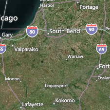
The National Weather Service has confirmed today that Monday night’s severe storms produced two tornadoes, one of which struck near Milford with high winds and additional damages affecting Syracuse. According to the NWS, the EF-0 tornado struck at 1:06 a.m. and was approximately 50 yards wide and traveled 1.9 miles hitting just west of Milford. The tornado …read more.
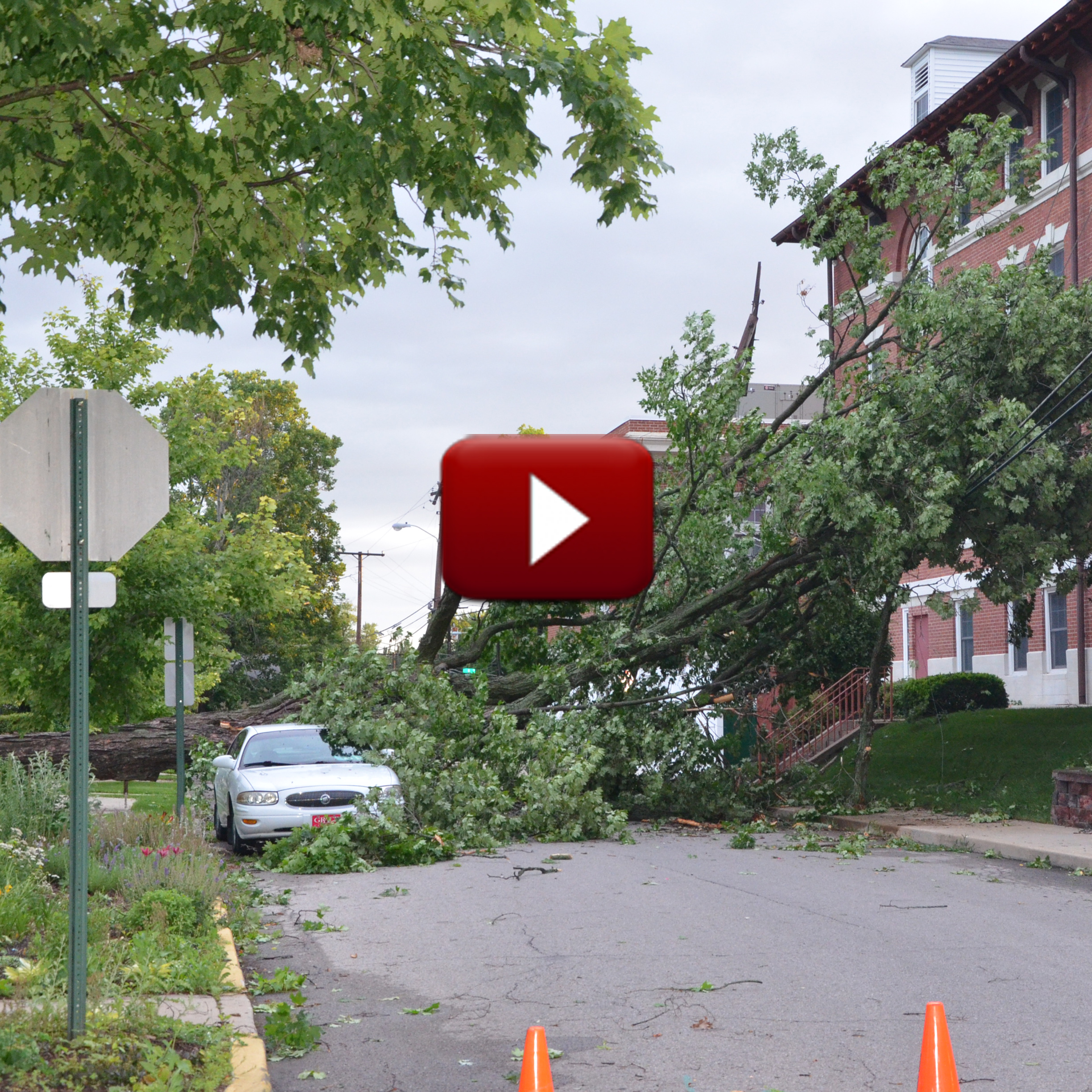
[weaver_youtube N3m4SWaonwE rel=0] This morning’s storm packed a one-two punch with two lines of storms bringing severe winds that have left numerous trees and power lines down throughout the county and thousands without power. Though many have speculated about the possibility of tornado touchdowns this morning, as of this time, meteorologists with the National Weather Service …read more.
The National Weather Service has issued a hazardous weather outlook for portions of northern Indiana and southwest lower Michigan. According to the NWS, there is a chance for thunderstorms through this afternoon with isolated wind gusts up to 60 mph possible within the strongest of the storm cells. Thunderstorms are expected tonight with a greater …read more.
A hazardous weather outlook has been issued for Kosciusko, Elkhart and Whitley counties. According to the National Weather Service, thunderstorms are expected today into this evening and a few storms could become severe. A threat of isolated damaging winds is present, primarily along and east of a Monticello to Goshen to Coldwater line. In addition, …read more.
The National Weather Service has now issued a Severe Thunderstorm Warning in effect until 3:30 p.m. EDT this afternoon for Kosciusko, Elkhart, Noble and LaGrange counties. At 2:36 p.m., severe thunderstorms were located along a line extending from Three Rivers to Bristol to Nappanee and moving East at 40 mph. The storm is packing wind gusts up …read more.
The National Weather Service has issued a Severe Thunderstorm Warning for Kosciusko County until 1:15 a.m. The storm was tracking from a path southwest of Bourbon at 35 mph and is bringing 60 mph winds and quarter-sized hail. Locations in the path of the storm include Etna Green, Hoffman Lake, Atwood, Hastings, Clunette, Monoquet and …read more.
This is Severe Weather Preparedness Week for Indiana and also National Flood Awareness Week. As such, Kosciusko County Emergency Management Director Ed Rock said a Tornado Drill has been scheduled for this week. Communities that have tornado sirens will undergo two tornado warning tests this Thursday. The first will happen around 10:30 a.m. and a …read more.
During a “normal” winter, Kosciusko County usually sees between 40 and 45 inches of total snowfall. This winter, however, said National Weather Service Meteorologist Nick Greenawalt, has been above normal in at least a few areas. The first measurable snowfall of the season — identified as the snow season — fell on Nov. 11, 2013, …read more.
Another blast of wintry weather has left Kosciusko County and surrounding areas under another blanket of snow, and rising temperatures through the week mean more melting snow and the threat of flooding. The National Weather Service in Northern Indiana has issued a Flood Warning for the Tippecanoe River near Ora that will affect Kosciusko, Fulton, …read more.
Up to 9 inches of snow is expected to dump over Kosciusko and surrounding counties overnight tonight which has prompted the National Weather Service in Northern Indiana to update a storm watch to a Winter Storm Warning. The warning goes into effect at 2 a.m. Wednesday. Heavy snow is expected late tonight and into Wednesday. …read more.

The National Weather Service has issued a Winter Storm Watch for Kosciusko and surrounding counties from late tomorrow night through Wednesday afternoon. According to meteorologists, a wintry mix of rain, snow and sleet is forecast to change over to all snow by late Tuesday night. Snow accumulations could reach between 4 and 8 inches by …read more.
A light dusting of snow is falling across areas of the county today. Though the snow has left some questioning if yet another winter storm is on its way, according to the National Weather Service, less than 1 inch is expected to fall. The NWS reports that snowfall is expected to occur primarily before 3 …read more.
The National Weather Service has issued a hazardous weather outlook for the northern Indiana area. Counties included in the outlook are Kosciusko, Elkhart, Marshall, Allen and Whitley. According to the NWS, accumulating snowfall is expected Saturday night through Sunday night with the heaviest snowfall to be over southern portions of the area. According to WSBT …read more.
Grab the hats and gloves again! The National Weather Service near North Webster has once again issued a Wind Chill Advisory for Kosciusko and surrounding counties. The advisory is for midnight tonight through noon Wednesday. Falling temperatures tonight combined with brisk west winds will result in wind chills from 10 to 20 degrees below zero …read more.
Although water is subsiding from area roads and fields, a Flood Warning has been extended for the Tippecanoe River near Ora through this weekend. The National Weather Service office near North Webster has extended the warning through 4 p.m. Sunday noting that, at 8 p.m. last night, the stage was 14.0 feet and steady. Flood …read more.
Record breaking cold temperatures and mounting snow accumulations has topped the news much of this winter and now, even with each day bringing us a little closer to spring, it seems the weather will continue to be a hot topic. Meteorologists at the National Weather Service near North Webster have today said that patchy blowing …read more.
Bundle up, another cold spell is coming. The National Weather Service has issued yet another Wind Chill Advisory. The advisory is for 8 p.m. tonight through 11 a.m. Friday when temperatures are will begin falling. Tonight’s low temperature of 9 below zero, combined with brisk winds that will continue through late Friday morning, will make …read more.
The National Weather Service has now issued a Wind Chill Advisory as efforts to dig out from a snow storm that dumped more than 13 inches of snow on parts of Kosciusko County continue. The advisory goes in effect from 5 a.m. to 2 p.m. Thursday and the forecast calls for temperatures to plummet to …read more.
The National Weather Service has issued a Winter Storm Warning for Kosciusko County from 1 p.m. today until 4 p.m. Wednesday. According to the NWS, the storm is expected to bring heavy snowfall as well as blowing and drifting snow. Very heavy snow is developing that will bring 1 to 2 inches of snow per …read more.
Gov. Mike Pence has directed the Indiana Department of Transportation to ready itself for a full call-out across most of the state as dangerous winter weather approaches. A Winter Storm Watch is set to go into effect at 1 p.m. Tuesday until 1 p.m. Wednesday. “As severe winter weather continues, INDOT remains fully prepared to …read more.
Total snow accumulations of 6 inches to 10 inches are possible in the latest system expected to move through northern Indiana, southern Michigan and northwest Ohio beginning Tuesday afternoon. The latest Winter Storm Watch issued by the National Weather Service office near North Webster is to go in effect Tuesday afternoon until approximately 1 p.m. …read more.
A recent post circulating across the Internet has left many believing a major snow storm will hit Kosciusko County this coming week. However, according to the National Weather Service, it is still too early for accurate predictions or snowfall estimates for the coming week. Though it is still unsure what to expect with next week’s …read more.
Strong winds and freezing cold temperatures have combined to put much of northern Indiana and southern Michigan into a deep freeze that will continue to dominate until at least Wednesday. The National Weather Service office in Syracuse has issued a Wind Chill Warning in effect now through noon Wednesday. Low temperatures at 15 below zero …read more.
The National Weather Service has placed much of northern Indiana, southern Michigan and northwestern Ohio under winter weather alerts, meaning accumulating snow and bitter cold temperatures for the next several days. A Winter Weather Advisory is now in effect until 7 a.m. Monday and a Wind Chill Watch will go into effect from Monday morning …read more.
A Wind Chill Advisory is in effect until 1 p.m. Friday. The National Weather Service has issued the advisory and cancelled the Winter Weather Advisory. This blast of Arctic air moving across the area will cause wind chills to plummet to 15 below to 25 degrees below zero. Exposed skin can suffer frostbite with extended …read more.
The National Weather Service has issued a Winter Weather Advisory for Kosciusko and surrounding counties until 10 a.m. Thursday. A burst of moderate snow will occur this evening with 1 inch to 2 inches of accumulation possible. Strong northwest winds will cause blowing and drifting snow as well as wind chills from 15 below to …read more.
Senior Meteorologist Sam Lashley with the National Weather Service Northern Indiana office near Syracuse, said the NWS is looking for volunteer rain and snow observers across the Michiana region. “Having a dense network of weather observers can help improve local forecasts and warnings and this gives people with weather interests a chance to get involved,” …read more.
A Blizzard Warning for much of northern Indiana has now expired, but the National Weather Service in Northern Indiana says a Winter Storm Warning remains in effect until 4 p.m. today. A Wind Chill Warning is also still in effect and will expire at 8 p.m. Tuesday. According to the NWS, blowing and drifting snow …read more.
With the large winter storm approaching our area, the American Red Cross in Kosciusko County has placed volunteers on alert and is prepared to respond as needed to storm-related emergencies. As with any disaster, preparation can be the difference between life and death. The Red Cross urges residents to be prepared — not only for …read more.
The National Weather Service overnight has upgraded a Winter Storm Watch to a Winter Storm Warning, meaning most of northern Indiana and southern Michigan will see snow accumulations of from 6 inches to 12 inches, beginning late tonight and early Sunday morning. Forecasters are calling this a potentially deadly winter storm. The upgraded winter event …read more.
(UPDATE: Warsaw Mayor Joe Thallemer announced this morning that the city will be opening up Center Lake Pavilion from 7 a.m. to 4 p.m. both Monday and Tuesday for residents needing shelter from the cold. Temperatures are expected to plummet to a high of -10 on Monday (windchill at -14) and -3 on Tuesday with a …read more.
As 2013 comes to a close, conditions may advance that foster the development of a significant winter storm. According to the National Weather Service (NWS), a potent upper level system is currently advancing into western British Columbia and may later develop into a significant winter storm. The NWS states that there is currently some indication …read more.
A Flood Warning remains in effect until 6 p.m. Sunday for Kosciusko, Marshall, Fulton, Starke, Pulaski, White, Cass, Miami and Wabash counties. The National Weather Service in Northern Indiana says up to 2 inches of rain has already fallen across the warning area and is expected to slowly diminish through the early morning hours. Runoff …read more.
The National Weather Service (NWS) has issued a “Special Weather Statement” for Kosciusko, Elkhart, Marshall, La Porte, St. Joseph, Starke, Cass and Berrien counties stating that a period of moderate to heavy snow is expected to develop after 4 p.m. today. According to the NWS, snowfall is expected to continue into the mid-evening tonight with …read more.
The weather outside is frightful and don’t look for it to get better anytime soon. The National Weather Service office in North Webster is forecasting single digit wind chills for the overnight hours tonight and then snow accumulations of up to 6 inches by next week. Friday through Sunday, look for the possibility of 4 …read more.
Bundle up before heading out this morning. Most of Northern Indiana is under a Wind Chill Advisory. The National Weather Service in Northern Indiana says the combination of overnight air temperatures dropping to around 0 overnight and a 10 mph wind have set the stage for dangerously cold wind chills this morning. A Wind Chill …read more.
A Freezing Rain Advisory has been issued for Kosciusko and surrounding counties for the remainder of tonight and into tomorrow morning. Light snow was mixing with or changing to freezing drizzle across portions of northern Indiana. Freezing drizzle is expected across the area as a low pressure system tracks northeast from the plains to the …read more.
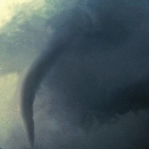
The National Weather Service is continuing its review of storm damages that occurred throughout Indiana Sunday and, as of late this afternoon, identified yet another tornado that struck Kosciusko County. The first tornado, an EF-2, was confirmed to have struck rural Silver Lake. This morning, the damages reported to The Pines housing addition north of …read more.
The National Weather Service has officially announced that it was a tornado that hit Silver Lake Sunday afternoon. The EF-2 tornado was estimated to have wind speeds of 125 mph and spanned 150 yards as it traveled on the ground for 4 miles. The tornado hit at about 3:43 p.m. along SR 15 just south …read more.

The National Weather Service Northern Indiana will have surveyors out today to determine if straight line winds or a tornado was responsible for wide-spread damages across Kosciusko County, Elkhart County, Fulton County and Huntington County among other areas. StaceyPageOnline.com will be out today finding some hard hit areas and talking with those affected. If …read more.
Graphic from the National Weather Service The National Weather Service has issued a tornado watch for Kosciusko and surrounding counties including Fulton, Marshall, Elkhart and Allen counties. The tornado watch is in effect until 8 p.m. tonight. The county remains under a wind advisory and severe weather watch throughout the evening (see related).
The National Weather Service has issued a wind advisory from 12 p.m. today until 10 p.m. Sunday evening. According to NOAA, southerly winds of 25-30 mph with gusts up to 50 mph are possible through Sunday afternoon and will turn westerly by Sunday evening. Higher gusts and significant wind damage will be possible with any …read more.
The National Weather Service is advising of the potential for a significant severe weather event in the Kosciusko and surrounding areas for Sunday, Nov. 17. The largest threats from these storms will be dangerous lightning, high winds and isolated tornadoes. The first signs of severe weather could be seen as early at 10 a.m. Sunday …read more.
Ghosts and ghouls won’t be the only things keeping people indoors today. According to the National Weather Service there is a chance of thunderstorms that will increase early this evening as a cold front approaches from the west. Though there is a small possibility that storms could be severe, the National Weather service reports damaging …read more.
As overnight temperatures are expected to dip below freezing, a freeze warning has been issued for Kosciusko County and surrounding areas. The National Weather Service office in Northern Indiana issued the freeze warning that will go into effect from 4 a.m. to 9 a.m. Tuesday. Overnight temperatures are expected to dip to as low as …read more.
After enjoying cooler temperatures throughout the majority of the month, August is going out with a bang. According to the National Weather Service, temperatures throughout August stayed primarily in the high 70’s and low 80’s. However, as the month neared its end, temperatures shot up into the high 80’s with humidity levels that brought the …read more.
Brace for high temperatures this week as the mercury reaches 90 most days and the heat index values could top 100 degrees. The National Weather Service in Northern Indiana says temperatures and dew points will increase throughout the week which will give heat index values near or above 100 degrees every day this week. The …read more.
Steady rain falling this morning has already resulted in local flooding problems and more issues are expected as the day progresses. In Warsaw, Columbia Street at the viaduct is flooded and closed to traffic. The 1700 block of East Market Street, in front of Warsaw Bowl, and Park Avenue from Market to Center streets are …read more.
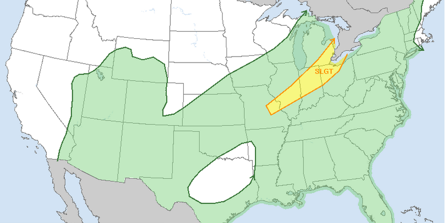
The National Weather Service Storm Prediction Center has now placed Northern Indiana under a high risk of severe weather for this afternoon and tonight. Strong storms are expected to quickly develop this afternoon and evening and produce damaging winds, large hail and the possibility of strong tornadoes. The areas most likely to experience severe weather …read more.
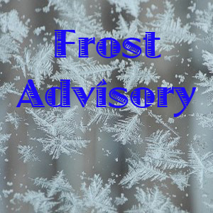
A Frost Advisory has been issued for Kosciusko and surrounding counties from 2 a.m. to 8 a.m. Saturday. The National Weather Service in Northern Indiana has issued the advisory as temperatures are expected to drop into the upper to middle 30s in the overnight hours. A Frost Advisory means frost is possible and sensitive outdoor …read more.
Kosciusko County is among 22 northern Indiana counties that is under a Severe Thunderstorm Watch now through early Tuesday morning. Indiana counties in the watch area also include Benton, Class, Elkhart, Fulton, Grant, Huntington, Jasper, LaGrange, Lake, LaPorte, Marshall, Miami, Newton, Noble, Porter, Pulaski, St. Joseph, Starke, Wabash, White and Whitley. A Severe Thunderstorm Watch …read more.

Overnight rain has attributed to even more flooding in the Kosciusko County area. Fortunately, there are now two locations in the county for residents feeling the affects of rising waters to get sand and sandbags to prevent damage to properties. The Barbee Chain of Lakes is being especially hit hard by flood waters. North Webster …read more.
Several county roads are flooded and closed due to rains that fell over northern Indiana over the past few days. The National Weather Service has also extended a Flood Warning for Kosciusko and surrounding counties until 5:15 a.m. Monday. Flooding in low lying areas is being reported. Several county roads have been closed due to …read more.
The National Weather Service has re-issued a Tornado Watch in effect for the following area counties until 5 p.m. today: Kosciusko, Elkhart, Fulton, Huntington, Lagrange, Marshall, Noble, Pulaski, St. Joseph, Starke, Wabash and Whitley. A watch mean conditions are favorable for storms that could produce tornadoes. A Wind Advisory is also in effect today. To …read more.
The National Weather Service in Northern Indiana has issued a wind advisory for Kosciusko and surrounding counties from 11a.m. to 8 p.m. today. South winds will be sustained at 20 to 25 mph with gusts up to 50 mph. Also in effect until Friday morning is a flood watch for much of northern and central …read more.
After an immensely difficult year for farmers and gardeners alike, this year’s growing season may promise better results. According to Michael Skipper with the National Weather Service in North Webster, last year’s planting season saw several factors that caused several farmers and gardeners problems. Skipper said March of last year was the warmest March month …read more.
The National Weather Service says a Winter Weather Advisory remains in effect for Kosciusko County and surrounding areas until 10 a.m. Monday. Snow is expected to being falling this evening and increase in intensity in the overnight hours. Total accumulations of 2 to 5 inches are possible by late Monday morning.

[youtube http://www.youtube.com/watch?v=e0r8S_Hu2tg] The streets of Warsaw bear a striking contrast to earlier this week as 10 inches of snow blankets much of the city. (photo by Alyssa Richardson) Looking at the snow covered streets of Warsaw, it is hard to believe that just two days ago snow was all but gone from Kosciusko County. However, …read more.
The National Weather Service is forecasting the heaviest of snow to fall between 6 p.m. this evening and midnight. A Winter Storm Warning will remain in effect until 4 a.m. tomorrow. Snow is expected to increase in coverage and intensity as the evening progresses. A total of 5 inches to 7 inches are expected to …read more.
The National Weather Service of Northern Indiana is forecasting as much as 4 inches to 9 inches of snow from a winter storm expected to impact Kosciusko County and surrounding areas Tuesday and Tuesday night. Now under a Winter Storm Warning, Kosciusko and surrounding counties are forecast to be hit with a system moving into …read more.
The National Weather Service is forecasting a winter storm for much of northern Indiana and southern Michigan Tuesday. The NWS has now changed the Winter Storm Watch to a Winter Weather Advisory to take effect at 10 a.m. Tuesday. It is currently set to expire at 12 a.m. Wednesday. The developing system could bring heavy …read more.
A Winter Weather Advisory has been issued for Kosciusko County for this evening through noon Friday. The National Weather Service in Northern Indiana issued the advisory for 8 p.m. tonight through noon Friday calling for snow and freezing drizzle. A band of snow is expected to move from southwest to northeast across the area overnight …read more.
The National Weather Service office in Syracuse has issued a Winter Weather Advisory for Kosciusko and surrounding counties in effect from 4 a.m. to 1 p.m. Monday. Snow is expected to start falling after 4 a.m. Monday and accumulate from 2 to 4 inches locally with greater amounts closer to Lake Michigan. Greatest accumulations are …read more.

A Flood Watch has been issued by the National Weather Service office in Syracuse for areas including Kosciusko, Elkhart, Fulton, Huntington, Lagrange, Marshall, Noble, Wabash and Whitley counties. The watch is in effect until 10 a.m. Wednesday and means that, which overnight rains, the potential for significant flooding is possible tonight and Wednesday morning. Periods …read more.
A Dense Fog Advisory issued by the National Weather Service office in Syracuse has now been extended until 4 a.m. Tuesday. Dense fog is causing widespread visibilities of a quarter-mile or less and conditions are expected to persist throughout the evening. Conditions are expected to improve in the overnight hours when winds increase and rain …read more.