Tag: NWS
The National Weather Service has issued a winter storm warning, in effect until 10 p.m. Saturday, Nov. 21, for Kosciusko and surrounding counties. Heavy snow is expected at times and will continue through the day before tapering off early this evening. Snow accumulations are expected from 4-7 inches through the evening. Snow covered roads …read more.
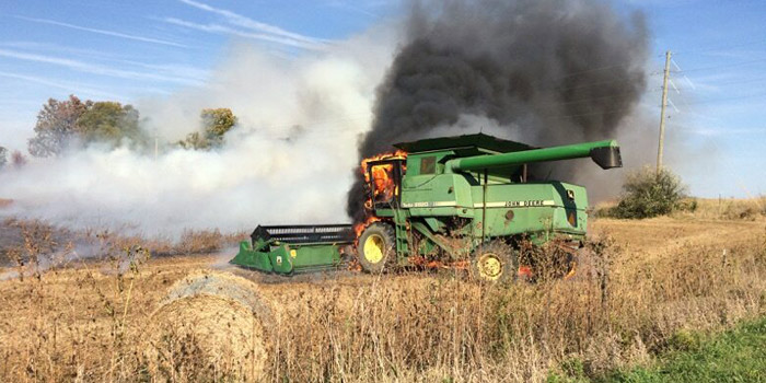
By JEFF BURBRINK, Extension Editor On Monday, Oct. 19, the National Weather Service issued a Red Flag Warning, which indicates the conditions were right for fires to spread rapidly due to dry conditions and wind. While conditions are expected to improve slightly over the next week, the fact is the fields are very dry …read more.
Extreme heat is on the horizon for Kosciusko County this weekend. The National Weather Service has issued a hazardous weather outlook for Kosciusko and surrounding counties. Today, thunderstorms are possible throughout the day and early tonight. An isolated strong or severe storm is possible along with localized heavy rain this afternoon and evening. This heat …read more.

UPDATE: Since the rain started, we have received reports of areas with standing water. A vehicle reportedly got stuck under the viaduct on Columbia Street. Several cars have been reported stalling out at intersections along Detroit Street through downtown Warsaw. Please use caution until water subsides. If you come upon an area of standing water, …read more.
The National Weather Service has issued a hazardous weather outlook for Kosciusko and surrounding counties. According to the NWS, chances for thunderstorms will increase late this morning and into the afternoon in advance of a cold front moving through the area. A few thunderstorms have the chance to become strong to severe in the afternoon …read more.
The National Weather Service has issued a frost advisory for Kosciusko and area counties from 2 a.m. to 9 a.m. Tuesday, April 28. According to the NWS, temperatures are expected to drop into the low to mid 30s tonight. Frost formation is likely once skies clear and winds diminish. The NWS notes that sensitive vegetation …read more.
The National Weather Service has issued a wind advisory, which is in effect from 11 a.m. to 8 p.m., for Kosciusko and surrounding counties. According to the NWS, strong winds of 20 to 30 mph are expected from the west with frequent gusts up to 45 mph expected late this morning and into the afternoon. …read more.
The National Weather Service in Northern Indiana has extended today’s wind advisory to 8 p.m. for Kosciusko and surrounding counties. According to the NWS, strong west winds between 25 and 35 mph are expected with frequent gusts up to 45 mph are expected later this afternoon and into the early evening. The NWS warns that …read more.
The National Weather Service Northern Indiana has issued a special weather statement for counties in northern Indiana including Elkhart, Fulton, Kosciusko, Noble, Whitley counties for a heightened fire danger this weekend. The danger will exist until approximately 8:15 p.m. Sunday. Recent rainfall has increased fine fuels moisture, however, a combination of humidity values in the …read more.
The National Weather Service has issued a special weather statement for Kosciusko and surrounding counties in regard to scattered thunderstorms moving through the area. According to the NWS, doppler radar has indicated showers and scattered thunderstorms along a line extending from Warsaw to 18 miles south of Grissom Airforce Base is moving east at 40 …read more.
The National Weather Service in northern Indiana has issued a winter weather advisory for freezing rain and sleet, which is in effect from 6 a.m. to 1 p.m. Tuesday. According to the NWS, freezing rain will spread from the southwest at 6 a.m. to the northeast by 9 a.m. The precipitation will start as a …read more.
The National Weather Service has issued a hazardous weather outlook for Kosciusko and area counties. According to the NWS, snow is expected to spread across the area early Tuesday morning. Accumulations of 1 to 2 inches are possible, especially closer to the Michigan state line. Snow should transition to a period of freezing rain from …read more.
The National Weather Service in northern Indiana has issued a winter weather advisory for snow and blowing snow in effect for Kosciusko and area counties until 10 p.m. According to the NWS, bands of light to moderate lake effect snow will develop this afternoon and persist through mid-evening. Snow accumulations of 1 to 2 inches …read more.
The National Weather Service has issued a hazardous weather outlook for area counties including Kosciusko, Marshall, Fulton, Wabash and Elkhart counties. According to the NWS snow showers are expected today, mainly over southern Michigan, which could cause some slick road conditions. Tomorrow through Monday wind chills of -15 to -24 degrees are expected with lake …read more.
The National Weather Service in northern Indiana has issued a winter weather advisory for snow and blowing snow for Kosciusko County to be in effect from 7 a.m. Saturday to 7 a.m. Sunday. According to the NWS, 1-4 inches of lake effect snow accumulation will occur mostly Saturday afternoon into Saturday night. While only light …read more.
The National Weather Service in northern Indiana has issued a winter weather advisory for snow, in effect from 12 p.m. to 7 p.m. today. According to the NWS, snow accumulations of 2-4 inches are expected with locally higher amounts possible. Snow may be briefly heavy at times with reduced visibilities. Untreated roads will become slippery …read more.
UPDATE: The National Weather Service has changed the possible snow accumulation totals from 7 to 11 inches to 10 to 15 inches. Please use caution while traveling this evening and tomorrow. The National Weather Service has issued a Winter Storm Warning in effect from 7 p.m. this evening to 4 a.m. Monday for the following …read more.
The National Weather Service has issued a Winter Storm Watch in effect from Saturday evening through Sunday evening for the following area counties: Kosciusko, Elkhart, Marshall, Fulton, Allen, Noble, Wabash and Miami. According to the NWS, heavy snowfall is expected with snowfall totals of 6-12 inches possible. Blowing and drifting snow, especially Sunday afternoon and …read more.
The National Weather Service in Northern Indiana has issued a freezing rain advisory in effect from 4 a.m. to 9 a.m. Thursday. According to the NWS, freezing rain is expected to develop later tonight into early Thursday morning before temperatures warm above freezing. Some snow and sleet may mix in at times. Light icing is …read more.
The National Weather Service in northern Indiana has issued a winter weather advisory for snow and blowing snow effective until 4 p.m. Friday. Dangerous cold conditions are expected with wind chills 10 to 25 below zero Friday into Saturday morning. According the the NWS, snow will develop late this afternoon or early this evening and …read more.
A wind chill warning was issued at 6:10 a.m. today by the National Weather Service and will be in effect from 10 p.m. this evening until noon Thursday. The winter weather advisory has been cancelled. In addition to Kosciusko County, other counties include Whitley and Allen counties. The snow will taper and end this morning, …read more.
The National Weather Service has issued a winter weather advisory in effect from 10 p.m. today until 10 a.m. Tuesday, for Kosciusko County as well as Whitley, Allen, Huntington, Wells and Adams counties among others. Snow is expected to overspread the area toward mid evening and continue into early Tuesday morning. Snowfall of 3 inches …read more.

The National Weather Service’s Northern Indiana Office in Syracuse is just one of the many that are trying to broaden its connection network throughout surrounding communities. The station covers 37 counties across Indiana, Michigan and Ohio. Warning Coordinator Meteorologist Michael Lewis explains that there are three main ways that the NWS gathers information. The first …read more.
The National Weather Service (NWS) has issued a freezing fog advisory in northern Indiana until 7 a.m. Saturday, Dec. 13. According to the NWS, areas of freezing fog with some patchy freezing drizzle will lead to slick spots on walkways and roadways. Localized visibilities are expected to be limited to a quarter of a mile. …read more.
The National Weather Service (NWS) has issued a special weather statement to be in effect until 8 p.m. this evening for Kosciusko and Whitley counties. According to the NWS, snow will continue to spread throughout northern Indiana late this afternoon and early this evening as an upper level disturbance tracks into the region. The accumulating …read more.
The National Weather Service has issued a hazardous weather outlook and special weather statement for the Kosciusko County area — specifically noting the cities of Ligonier, Plymouth, Bremen, Culver, Warsaw, Winona Lake, Syracuse, Mentone, Columbia City, South Whitley and Fort Wayne. According to the NWS, lake effect snow showers will increase throughout the day and …read more.
As trick-or-treaters prepare to don their costumes throughout Kosciusko County this evening, parents may also want to grab a coat and umbrella. The National Weather Service is predicting both rain and showers today with a high near 42 degrees. According to the NWS, rain or snow showers are likely before 10 p.m., then scatter snow …read more.
The National Weather Service has issued a hazardous weather outlook for portions of northern Indiana and southwest lower Michigan. According to the NWS, there is a chance for thunderstorms through this afternoon with isolated wind gusts up to 60 mph possible within the strongest of the storm cells. Thunderstorms are expected tonight with a greater …read more.
A hazardous weather outlook has been issued for Kosciusko, Elkhart and Whitley counties. According to the National Weather Service, thunderstorms are expected today into this evening and a few storms could become severe. A threat of isolated damaging winds is present, primarily along and east of a Monticello to Goshen to Coldwater line. In addition, …read more.
A light dusting of snow is falling across areas of the county today. Though the snow has left some questioning if yet another winter storm is on its way, according to the National Weather Service, less than 1 inch is expected to fall. The NWS reports that snowfall is expected to occur primarily before 3 …read more.
The National Weather Service has issued a Winter Storm Warning for Kosciusko County from 1 p.m. today until 4 p.m. Wednesday. According to the NWS, the storm is expected to bring heavy snowfall as well as blowing and drifting snow. Very heavy snow is developing that will bring 1 to 2 inches of snow per …read more.
A recent post circulating across the Internet has left many believing a major snow storm will hit Kosciusko County this coming week. However, according to the National Weather Service, it is still too early for accurate predictions or snowfall estimates for the coming week. Though it is still unsure what to expect with next week’s …read more.
(UPDATE: Warsaw Mayor Joe Thallemer announced this morning that the city will be opening up Center Lake Pavilion from 7 a.m. to 4 p.m. both Monday and Tuesday for residents needing shelter from the cold. Temperatures are expected to plummet to a high of -10 on Monday (windchill at -14) and -3 on Tuesday with a …read more.

Heavy snowfall during the overnight and morning hours in the Northeast Indiana District of the Indiana Department of Transportation has made for difficult driving condition on most interstates, U.S. highways, and state routes across the area, despite a full callout of plow trucks on the roads. According to the National Weather Service light snow and …read more.
The Winter Weather Advisory issued by the National Weather Service Northern Indiana has extended the advisory to 4 p.m. Thursday. The snow is expected to expand across northern Indiana and northwestern Ohio tonight through Thursday afternoon. NWS is stating the band of light to moderate snow across far southern lower Michigan falling this afternoon will …read more.
As 2013 comes to a close, conditions may advance that foster the development of a significant winter storm. According to the National Weather Service (NWS), a potent upper level system is currently advancing into western British Columbia and may later develop into a significant winter storm. The NWS states that there is currently some indication …read more.
Nearly quarter of Indiana labeled extreme drought INDIANAPOLIS (AP) — A federal report now lists nearly a quarter of Indiana as being in extreme drought as much of the state faces the driest June on record. The new U.S. Drought Monitor map released Thursday shows counties in the Evansville area and much of the area …read more.