Tag: hazardous weather outlook
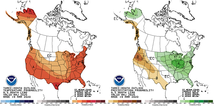
NORTH WEBSTER — Expect a likelihood of above-normal temps and precipitation through spring into early summer. According to the National Weather Service, the three-month seasonal outlook for April – June 2020 may see a near 50% chance of above-normal temps in the region. A high of 70 would be a normal maximum temperature. A low …read more.
WARSAW – Lake effect snow showers will continue to move across parts of Northern Indiana Thursday, Feb. 27, and could cause some drifting snow. The National Weather Service has issued a hazardous weather outlook and warns that drifting snow will likely hamper travel over rural and open roads. Across the region, additional snow accumulations are …read more.
KOSCIUSKO — Kosciusko County is included in a hazardous weather outlook issued by the National Weather Service for this weekend. This hazardous weather outlook is for portions of southwest Michigan, northern Indiana and northwest Ohio. Dry but cool weather is expected today, with highs reaching around the 40 degree mark. A wintry mix will move …read more.
KOSCIUSKO — The National Weather Service has issued a hazardous weather outlook for portions of southwest Michigan, northwest Ohio and northern Indiana, including Kosciusko and surrounding counties. Runoff from recent snowmelt and rainfall today, Monday, Jan. 22, may lead to some minor flooding of rivers and streams later this week. Isolated ice jam flooding is …read more.
KOSCIUSKO — The National Weather Service has issued a hazardous weather outlook for Kosciusko and surrounding counties. Patchy, dense fog will be possible through the remainder of this evening. Rain will change over over to a period of sleet and freezing rain late Thursday evening through early Friday morning, before changing over to snow. Some …read more.
KOSCIUSKO — The National Weather Service has issued another wind chill advisory for Kosciusko and surrounding counties, this one in effect until 11 a.m. Friday, Jan. 5. Very cold winds, with wind chills ranging from 0 to 20 below zero are expected. Frostbite and hypothermia can occur if precautions are not taken. Make sure you wear …read more.
NORTHERN INDIANA — 2018 is starting on a bitterly cold note with high temperatures struggling out of the single digits for most areas. The National Weather Service in Northern Indiana has issued a hazardous weather outlook for much of the area, including Kosciusko and surrounding counties. Bitterly cold temperatures are expected all day Monday, Jan. 1, …read more.
WARSAW — The National Weather Service has issued a dense fog advisory for Kosciusko County, including Warsaw, Winona Lake and Syracuse, until 1 a.m. Tuesday. Widespread fog with areas of dense fog can be expected through this evening. According to the NWS, visibility will be a quarter mile or less at times. Hazardous driving conditions are …read more.
KOSCIUSKO COUNTY — While Kosciusko County and surrounding counties remain under a hazardous weather outlook, areas to the west are beginning to see an increase in severe weather risk. The National Weather Service has issued a tornado watch for several counties along the western edge of Indiana, including Benton, Newton, Jasper, Porter and Lake counties. This will …read more.
NORTHERN INDIANA — The National Weather Service of Northern Indiana has issued a hazardous weather outlook today, Monday, June 20, for Kosciusko and surrounding counties. Heat indices are expected to reach into the low- to mid-90s range. Scattered, isolated thunderstorms could develop after 2 p.m. and some could be strong or severe. Click here for …read more.
NORTHERN INDIANA — The National Weather Service has issued a hazardous weather outlook for Kosciusko and surrounding counties. This means there is a slight chance for showers throughout the day, with thunderstorms this afternoon and evening; it does not mean severe weather is currently expected. There is also a chance for an occasional thunderstorms through Sunday …read more.
NORTHERN INDIANA — The National Weather Service of Northern Indiana has issued a hazardous weather outlook for Kosciusko County and surrounding counties, including but not limited to Whitley, Elkhart, Fulton, Allen and Marshall. Snow showers are expected throughout the northern Indiana area this afternoon and wind and snow could cause reduced visibility in some areas. Isolated thunderstorms …read more.
NORTHERN INDIANA — The National Weather Service in Northern Indiana has issued a hazardous weather outlook for much of the area, including Kosciusko and surrounding counties. Thunderstorms are likely this afternoon, Thursday, March 31. Some of these thunderstorms may be severe, with large hail and isolated damaging winds. Windy conditions are also predicted Friday through …read more.
NORTHERN INDIANA — The National Weather Service Northern Indiana has issued a special weather statement and hazardous weather outlook for Kosciusko, southern Marshall, Fulton counties as well as portions of Starke, Pulaski, White and Counties. Portions of Elkhart and Noble counties are in a severe thunderstorm warning. NWS reported a line of strong thunderstorms will …read more.
NORTHERN INDIANA — The National Weather Service of Northern Indiana has issued a hazardous weather outlook for Kosciusko, Whitley, Allen, St. Joseph, Elkhart, LaGrange, Fulton, Marshall, Pulaski, Starke, Noble, DeKalb, Cass, Miami, Wabash and White Counties. Light snow is expected to overspread the region late tonight. Some light freezing rain or freezing drizzle may also …read more.

By JEFF BURBRINK Extension Educator, Purdue Extension Elkhart County GOSHEN — While our snowfall totals have not been much to talk about this winter, we have had a lot of blustery days since the beginning of the year. Between Jan. 1 and Feb. 29, 51 of the 60 days recorded gusts over 20 miles per hour, while 33 of those 60 days averaged more than 10 miles per hour at the South Bend airport.
NORTHERN INDIANA — The National Weather Service has issued a hazardous weather outlook for portions of northwest Ohio and northern Indiana on Tuesday. The counties included include Noble, DeKalb, Starke, Pulaski, Marshall, Fulton, Kosciusko, Whitley, Allen, White, Cass, Miami, Wabash, Huntington, Wells, Adams, Grant, Blackford, Jay and Fulton counties in Indiana. A mix of snow, …read more.
NORTHERN INDIANA — The National Weather Service of Northern Indiana has issued a hazardous weather outlook for most of Northern Indiana at 5:05 p.m. this evening. While no hazardous weather is expected tonight and during the day on Tuesday, there is a chance of snow late Tuesday night across far Northern Indiana, extreme Northwest Ohio …read more.
NORTHERN INDIANA — The National Weather Service has issued a hazardous weather outlook for the following counties: Kosciusko, Marshall, LaGrange, Noble and St. Joseph. This includes the areas of Warsaw, Winona Lake, Syracuse, Mentone, Plymouth, Bremen, Culver, LaGrange, Topeka, Shipshewana, Kendallville, Ligonier and Albion and portions of southern Michigan. Lake-effect snow showers will diminish later …read more.
NORTHERN INDIANA — The National Weather Service of Northern Indiana has issued a winter weather outlook for Kosciusko County and the following surrounding counties: Marshall, Elkhart, Noble, Whitley, Wabash and Fulton. The Marshall County Sheriff’s Department and Noble County EMA and 911 Center have issued the following statement for their areas: A winter storm watch …read more.
NORTHERN INDIANA — The National Weather Service has issued freezing rain and wind advisories and a hazardous weather outlook, all in effect throughout today, Monday, Dec. 28. The freezing rain advisory lasts until 4 p.m. and includes light ice accumulations up to 1/10 of an inch. The freezing rain is expected to change to rain later …read more.
NORTHERN INDIANA — The National Weather Service, Northern Indiana, issued a hazardous weather outlook at 4:05 p.m. today, Dec. 2. Kosciusko, Noble, Marshall, Fulton, and Whitley counties are included in that outlook. NWS reports scattered snow showers are expected into the early evening with little to no accumulation. Roads should remain mainly wet, but slick …read more.
The National Weather Service has issued a hazardous weather outlook for portions of northern Indiana. Severe thunderstorms are possible throughout the day and into the night. Heavy, damaging winds could accompany the storms. There is also a risk of large hail, and isolated tornadoes could touch down. Heavy rainfall may come down throughout the day, …read more.
The National Weather Service has issues a hazardous weather outlook for portions of northern Indiana. Scattered and numerous thunderstorms are expected from late this morning through the evening. Thunderstorms could be severe in the evening, with heavy wind gusts. Hail is also possible. Heavy downpours could add to flooding issues already affecting the area. Additionally, …read more.
UPDATE: The hazardous weather outlook has been upgraded to a severe thunderstorm warning. A severe thunderstorm could move through Kosciusko County. Strong winds and hail could accompany the storm. Should the storm hit in your area, move to an interior room on the lowest floor of the building. Flash flooding could occur. NWS warns not …read more.
The National Weather Service has issued a special weather statement for portions of northern Indiana. Thunderstorms are expected across northeast Indiana this afternoon and through the evening. Storms could be accompanied by damaging winds. NWS reports that stronger storms could produce winds up to 50 mph. There is also a slight chance of small hail. …read more.
The National Weather Service has issued a hazardous weather outlook for Kosciusko and surrounding counties. According to the NWS, chances for thunderstorms will increase late this morning and into the afternoon in advance of a cold front moving through the area. A few thunderstorms have the chance to become strong to severe in the afternoon …read more.
The National Weather Service has issued a hazardous weather outlook for Kosciusko and surrounding counties. According to the NWS, west winds of 15 to 25 mph with gusts of 35 to 40 mph are expected late this morning and afternoon. Lows are expected to be in the lower 30s tonight with frost and sub-freezing temperatures …read more.
The National Weather Service has issues a hazardous weather outlook and special weather statement for northern Indiana. Periods of snow can be expected during the day throughout the region. Accumulations of 1 to 3 inches may be possible on grassy areas, and slick road conditions could occur during heavier periods of snowfall. The snow is …read more.
The National Weather Service has issued a hazardous weather outlook for portions of northern Indiana. Melting snow combined with frozen ground is expected to water ponding in areas with poor drainage. Additionally, rapid river level rises could occur in areas prone to ice jams. Kosciusko, Elkhart, Marshall, Fulton, Whitley and Noble Counties are affected by …read more.
The National Weather Service has issued a hazardous weather outlook for Kosciusko and area counties. According to the NWS, snow is expected to spread across the area early Tuesday morning. Accumulations of 1 to 2 inches are possible, especially closer to the Michigan state line. Snow should transition to a period of freezing rain from …read more.
The National Weather Service has issued a wind chill advisory for portions of northern Indiana and southern Michigan. The advisory goes into effect at 4 p.m. today and should last until noon tomorrow. NWS is forecasting wind chill values between 10 below zero and 25 below zero. These conditions are expected to set in this …read more.
According to Ed Rock of the Kosciusko County Emergency Management Department, Kosciusko County will remain under the red warning/declaration through the night. A re-evaluation will take place after the county plows have had a chance to observe and report.
The National Weather Service has issued a hazardous weather outlook for portions of northern Indiana. Lake effect snow is expected later tonight. Heaviest accumulations are expected in St. Joseph and La Porte Counties, but Kosciusko, Elkhart, Marshall and Fulton Counties will also be affected by these weather patterns. There is a possibility of blowing snow …read more.
The National Weather Service has issued a hazardous weather outlook for northern Indiana, including Kosciusko, Elkhart, Whitley, Marshall, Noble, St. Joseph, and Allen Counties, until late Thursday morning. The outlook calls for lake effect snow showers through tonight with an additional one to three inches of accumulation possible in areas favored by northwest winds. Wind …read more.
The National Weather Service has issued a hazardous weather outlook and special weather statement for portions of northern Indiana and southwest Michigan. Snow coming up from the south is expected to overspread the area. Two to four inches of snow, possibly mixed with sleet and freezing rain, is expected to come down over the region …read more.
Indiana Department of Transportation maintenance supervisors are closely monitoring local forecasts for a weekend storm system that could bring periods of rain, freezing rain and snow. INDOT will deploy its yellow salt trucks ahead of any predicted accumulation on Indiana’s interstates, U.S. highways and state routes. INDOT will adjust its call out of manpower, trucks …read more.
At approximately 10 a.m. this morning, the National Weather Service issued a hazardous weather outlook for portions of northern Indiana and southwest Michigan. The outlook projects that wind chills will fall to between 0 degrees and 10-below later this evening. Wind chill temperatures are expected to be below zero for much of Tuesday as well. …read more.
The National Weather Service has issued a hazardous weather outlook for portions of northern Indiana, including Kosciusko County and some neighboring counties, southwest lower Michigan and northwest Ohio. Thunderstorms are expected in these regions through the rest of the day and into the night. NWS is projecting heavy rainfall, one to three inches, and the …read more.