National Weather Service — A Part Of The Lakeland Area For Almost 20 Years

(EDITOR’S NOTE: This is the first of a four-part series on the National Weather Service, Northern Indiana)
SYRACUSE—The National Weather Service, Northern Indiana, has been a part of the Lakeland Area for close to 20 years. How did it get to this area?
Michael Lewis, warning coordination meteorologist at NWS, said the National Weather Service has been around since World War II, original a part of the Army Signal Corp, then it became the weather bureau until the 1960s. During the John F. Kennedy days the weather bureau transitioned to be more service based. Lewis noted there were a lot of little weather service officers at major airports.
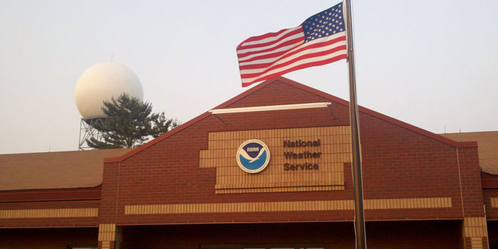
In the 1980s a major revision on the structure of the NWS was reviewed with the new technology coming out. That technology being the radar, which can be seen sitting in “the back 40” at the NWS station on SR 13 between Syracuse and North Webster. “That radar changed the way we needed to work the foot print – how it worked and where we can see,” said Lewis.
Consolidation was the answer. Several hundred weather offices were reduced to 122 weather service warning offices. “Where we used to be anchored to major air ports, now we’re anchored to the radar,” Lewis said.
According to Lewis, there was a weather service office in South Bend, another in Fort Wayne. “There wasn’t a plan to have a radar here,” Lewis said. But there would be a large gap in coverage by taking either office out of the mix. The gap would be prediction of lake effect snow, captured by the South Bend radar and the severe weather around the Fort Wayne area. “It then became politicized,” Lewis noted. “They said we need to do something. But where should it be? A compromise was reached. We don’t want to be so close to the lake that we miss the stuff that’s across the area. We don’t want to be in Fort Wayne because we’ll miss the lake.”
What happened was the NWS was given a land lease on the Tri-County Game Preserve. That property was later given to the government agency. “I credit the folks who really pushed for it,” said Lewis.
The location, which also happens to be on the continental divide, fills a huge void that would have happened otherwise. “We also found here, the rivers are a critical part. There is a lot of flooding, so the radar is helpful with that and having a local office responsible for monitoring and maintaining the forecast on those rivers is crucial. Had we not have the office here, that stuff would be a little less served, the quality of service harder to do.”
The actual Doppler Radar Dome was erected on June 27, 1997, during a ground breaking ceremony. The radar was attached to a permanent facility by June 1998. An open house was held in October 1999.
But disharmony over its name and location soon caused a storm of controversy.
The facility has a Syracuse address, receives mail in North Webster. It was often confused with Syracuse, N.Y. So it took on the name of National Weather Service, Northern Indiana.
Officials worked with its partners in the lower five counties in Michigan and eight western counties in Ohio, assuring them they were not getting the “short shrift,” or lesser forecasts.
Lewis stated the 37 counties it serves receive uniformity and consistent forecasts. “It’s a priority for us each receive the same level of service. Political boundaries don’t matter to us. We see it as a place that we forecast for and a service we provide, regardless of where you lie on the map.”